The centre, along the road
Bach
Pòch in the Sappada dialectHamlet of Sappada
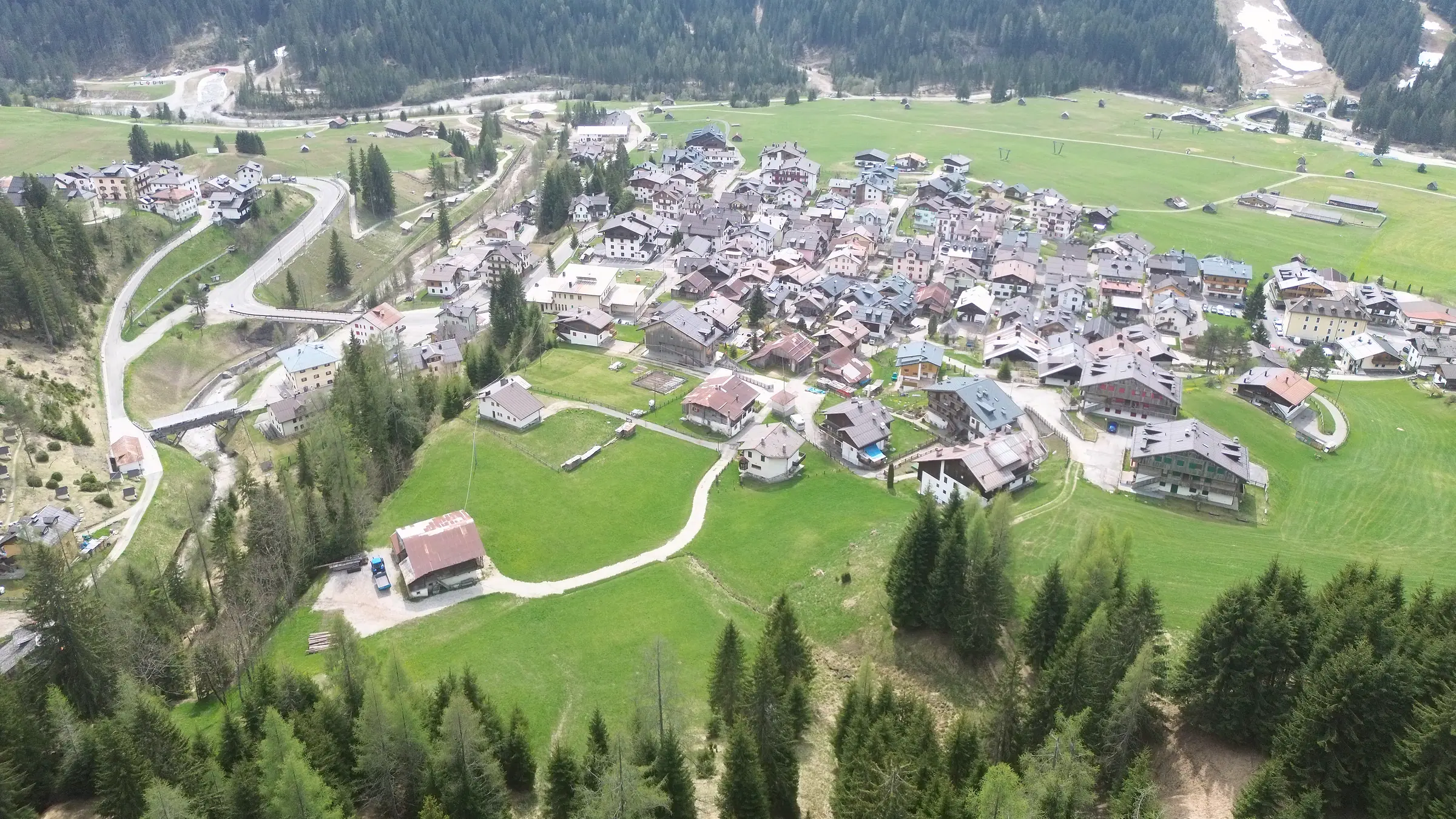
Bach, Pòch in Plodarisch, is the hamlet where Sappada works as a town: the town hall, post office, pharmacy, shops and nursery ski slopes are here, at 1,254 m. It burned down in 1908 and was rebuilt in masonry in parallel rows, so little old timber is left. People who choose it want to do everything on foot and, in December, get more sun than almost any other hamlet; in return they accept the regional road running between the houses.

The sun here
Where the sun reaches Bach from, and when
The ridge line you see is the real one, calculated from the centre of the hamlet. Above it are the sun's paths on the days that matter: where the line is solid the sun is in view, where it is dashed the sun has risen but is still behind the mountain.
On 21 December the sun reaches Bach at about 10:00 and leaves at about 15:20: about 5 h 20 min of direct sun, under a clear sky.
Move your mouse or finger over the panorama, or use the slider beside it: you can read the direction, the height of the ridge, the peak, and the time the sun passes that way.
In words: from Bach the highest stretch of ridge lies to the north-west, 25.4° above the horizon; the lowest to the east, 2.9°. To the south the ridge stands at 18°, and at midday on 21 December the sun climbs to 20°. At midday on that day the sun is in view. On 21 December it arrives at about 10:00 and leaves at about 15:20; on 21 June it stays in view from roughly 6:00 to 19:55.
Hours of direct sun, month by month
On the 21st of each month, under a clear sky, at the centre of the hamlet. The pale band is the day as it would be without mountains: the difference is what the ridge takes away.
- direct sun in Bach
- the day without mountains
- average of the hamlets
The same figures as a table
| Day | Direct sun | First light | Last light | Without mountains | Average of the hamlets |
|---|---|---|---|---|---|
| 21 January | 5 h 35 min | 10:05 | 15:40 | 9 h 08 min | 5 h 15 min |
| 21 February | 7 h 30 min | 8:15 | 16:55 | 10 h 36 min | 8 h 05 min |
| 21 March | 10 h 35 min | 6:35 | 17:10 | 12 h 08 min | 10 h 25 min |
| 21 April | 12 h 50 min | 6:40 | 19:25 | 13 h 49 min | 12 h 25 min |
| 21 May | 13 h 30 min | 6:15 | 19:45 | 15 h 10 min | 13 h 10 min |
| 21 June | 13 h 55 min | 6:00 | 19:55 | 15 h 46 min | 13 h 35 min |
| 21 July | 13 h 35 min | 6:25 | 19:55 | 15 h 13 min | 13 h 15 min |
| 21 August | 12 h 50 min | 6:40 | 19:30 | 13 h 52 min | 12 h 25 min |
| 21 September | 10 h 35 min | 7:20 | 17:55 | 12 h 12 min | 10 h 30 min |
| 21 October | 7 h 15 min | 8:45 | 17:20 | 10 h 35 min | 8 h |
| 21 November | 5 h 35 min | 9:40 | 15:15 | 9 h 08 min | 5 h 15 min |
| 21 December | 5 h 20 min | 10:00 | 15:20 | 8 h 30 min | 3 h 45 min |
21 December, the shortest day
- First light
- 10:00at about
- Last light
- 15:20at about
- Direct sun
- 5 h 20 minabout
- Without mountains the day would last 8 h 30 min: the ridge takes away 3 h 10 min.
- Across the 168 mapped buildings of the hamlet, direct sun ranges from 4 h 55 min to 5 h 20 min; the mid-point is 5 h 15 min.
- At midday the sun is in view all year round.
- What hides it longest is the ridge to the south-east, where Monte Siera stands: about 2 h 10 min.
The peaks in view from Bach
According to the calculation: at least twenty metres of summit above the terrain in between. A wood or a nearby house can still hide them.
The list of peaks in view
| Peak | Direction | Distance | Altitude |
|---|---|---|---|
| Monte Tuglia | E · 90° | 6.2 km | 1,945 m |
| Monte Cimon | E · 106° | 6.2 km | 2,415 m |
| Monte Siera | SE · 134° | 2.7 km | 2,443 m |
| Creton di Clap Grande | S · 195° | 4.3 km | 2,487 m |
| Terza Piccola | W · 261° | 4.7 km | 2,336 m |
| Monte del Ferro | NW · 325° | 2.3 km | 2,347 m |
Names and altitudes are those of OpenStreetMap. Peaks beyond the basin are left out: they are long lines of sight that need checking on the spot before we state them.
MethodA calculation, not a measurement: terrain model at 10 m, clear sky, the centre of the hamlet with the eye 6 m above the ground. Trees and buildings are not counted; times are rounded to five minutes and, where the sun skims a ridge, they can shift by ten to twenty.
Sources and details of the calculation
Times are Italian local time (summer time from late March to late October), calculated for the year 2027; the sun counts as present when the centre of its disc is above the ridge. On 21 September the sun's path is almost the same as on 21 March, an hour later by the clock. Calculated on 7 October 2026.
- Tarquini S., I. Isola, M. Favalli, A. Battistini, G. Dotta (2023). TINITALY, a digital elevation model of Italy with a 10 meters cell size (Version 1.1). Istituto Nazionale di Geofisica e Vulcanologia (INGV). doi.org/10.13127/tinitaly/1.1
- produced using Copernicus WorldDEM-30 © DLR e.V. 2010-2014 and © Airbus Defence and Space GmbH 2014-2018 provided under COPERNICUS by the European Union and ESA; all rights reserved
- Borgate e cime: © OpenStreetMap contributors, ODbL 1.0 — www.openstreetmap.org/copyright
- Posizione del sole: NOAA Global Monitoring Laboratory, Solar Calculator (gml.noaa.gov/grad/solcalc/), da J. Meeus, «Astronomical Algorithms»
What Bach is like
What kind of place it is
The name comes from the stream: Bach in German, Pòch in Plodarisch, the local German dialect. This is the hamlet of the municipal seat: the town hall has been here since 1953; before that it was in Mühlbach, in the school building. Around it are the post office, the pharmacy, the library, the tourist office, the supermarket and most of the shops.
Bach differs from the hamlets on the old road because it burned. The fire of 13 September 1908 started in a hay barn; the rebuilding redrew the settlement further down the slope, in three parallel rows of masonry houses, with two rows of farm buildings above them that in recent decades have almost all become dwellings. The “new road” of 1922, today regional road 355, runs between the second and third rows: it is the reason the services are here, and also the reason for the traffic in the busy weeks.
The municipal land-use plan does not treat this rebuilding as ordinary construction: it calls it “rifabbrico”, places it in a historic zone of its own and recognises its value as a record of its time.
The sun: what the calculation says
On 21 December, according to our calculation, the hamlet's map point receives about 5 h 20 min of direct sun: it arrives at around 10:00, when it clears Monte Siera, and leaves at around 15:20, behind the Terze peaks. On that date only Pill, the hamlet next door, receives more. On 21 March the figure is about 10 h 35 min, on 21 June about 13 h 55 min.
This is a calculation on the terrain model, under a clear sky, for one point: it sees neither trees nor buildings. In Bach that matters more than elsewhere, because the houses stand in rows one in front of the other: in December the sun is only 20° above the horizon and a building casts a shadow almost three times its own height. A ground floor with a house in front can be in shade even here; the lower rows towards the Piave get a little less sun than the upper ones. What to do is simple: look at the house on a clear winter day, or ask the people who live there what time the sun reaches the balcony.
What you see
The view is to the south, in the same direction as the sun. To the south-east is Monte Siera, the mountain that dominates the village; straight ahead, the Clap group; to the south-west the Terze, behind which the sun sets in winter. Behind the hamlet rises the slope of Monte Ferro. Monte Peralba (2,694 m) cannot be seen from Bach: it is visible only from Cima Sappada.
These are the peaks the calculation gives as visible from the hamlet's map point. What you see from a particular window depends on what stands in front of it: the land-use plan protects the valley-floor meadows, not the view from an individual house.
The houses, and what comes up for sale
Mostly apartments: in the houses of the rebuilding, in apartment blocks from the second half of the twentieth century, in attics, in a few buildings from the 1990s with a basement room and a garage. Of the old timber, one house and one barn with hayloft remain, and on the old road the chapel of St Anthony of Padua, from 1726: it is the oldest chapel in Sappada. The buildings stand between 1,235 m and 1,268 m.
Listings sometimes say “Bach alta” (upper Bach): it is not an official place name, it means the rows higher up, towards the old road. In Sappada an address is “Borgata” plus the house number, and the same name covers the part on the regional road and the part above it: always ask where the house actually stands.
For the Italian Revenue Agency Bach is the “central” zone of the municipality: standard homes are valued between €2,000/m2 and €3,000/m2 (OMI, normal condition, gross floor area). It is a range estimated on completed sales, not the price of a house; asking prices in listings are a different measure and sit higher.
On foot from here
From Bach you can do on foot almost everything you need in a week's holiday and much of what you need to live here: food shopping, pharmacy, post office, doctor, nursery school; the primary and lower secondary schools are in neighbouring Mühlbach. The stop for the scheduled buses, to Tolmezzo and to Calalzo, is in the hamlet.
What is not within walking distance: a large supermarket (for the big shop people drive down to Santo Stefano di Cadore), upper secondary schools, a hospital. Parking, in the peak weeks, is the problem of the whole centre; the land-use plan provides for an underground car park with a small market square, but we cannot say whether or when it will be built.
In winter
The Campetti, the two drag lifts of the nursery slopes, are on the meadows below the houses: the upper end, on the village side, is a few minutes' walk away. Next to them is Nevelandia, the snow play park. For anyone learning to ski, or with small children, it is the most convenient position in the village.
For the chairlifts you have to travel: Sappada 2000 starts from Kratten, further east; Pian dei Nidi from the level ground below Soravia; Monte Siera from Cima Sappada; Eiben from across the Piave. Ski-pass holders use the free ski bus, whose stops and timetable should be checked again each season. We do not write “linked ski area”: no ski-in, ski-out connection between the sectors is documented. The cross-country trail, 13 km in all, runs along the valley floor: the stadium is on the level ground below the hamlets from Hoffe to Soravia.
1,254 mSource 3OpenStreetMap, the hamlet's node, with the altitude from the EU-DEM 25 m model (OpenTopoData); data © OpenStreetMap contributors, ODbL · 6 October 2026
Altitude of the hamlet
The hamlet's point on OpenStreetMap; the houses stand between 1,235 m and 1,268 m.
Direct sun on 21 December
Calculated on the terrain model, under a clear sky, for the hamlet's map point: trees and buildings are not taken into account. Read it as “about”.
| Item | Pill | Bach | Mühlbach |
|---|---|---|---|
| Altitude | 1,251 m | 1,254 m | 1,243 m |
| Sun on 21 December (calculated) | 5 h 30 min | 5 h 20 min | 4 h 55 min |
| Regional road | further down | between the houses | touches the lower part |
| Houses | timber, 18th and 19th century | masonry, after 1908 | a few in timber, then 1930s–1950s |
The same fields for all three. Hours of sun refer to the hamlet's map point.
On foot from here
- the town hall, post office, pharmacy and library
- the supermarket, the bakeries, the sports shops
- the tourist office, in Borgata Bach
- the Campetti and Nevelandia, on the meadows below the houses
- the stop for scheduled buses and the ski bus stop
The drawback
The regional road runs between the houses: in the peak weeks there is traffic, noise and little parking. In houses on the road, check which side the bedrooms are on.


Who it suits
Who Bach suits, and who it does not
It suits you if
- Anyone who wants to do everything on foot, even without using the car on holiday.
- Families with small children: nursery slopes, snow park and shops are here.
- Anyone letting the house: the position explains itself, in every season.
- Anyone who puts December sun at the top of the list.
Look elsewhere if
- Anyone looking for the old road and period timber houses: one house and one barn are left here.
- Anyone who wants to stay away from the traffic of the busy weeks.
- The skier who wants a chairlift on the doorstep: the chairlifts start elsewhere.
The drawbacks, stated
- The regional road runs through the middle of the hamlet: traffic and noise in the busy weeks, difficult parking in season.
- Few historic houses: the fire of 13 September 1908 changed the face of the hamlet, and the layout in parallel rows is rigid.
- The houses stand one in front of the other: on the lower floors, December sun depends on the building opposite more than on the mountain.
- The chairlifts are not within walking distance: the hamlet has only the drag lifts of the nursery slopes.
Prices
How the Italian Revenue Agency values this area
Bach falls within the zone that the property market observatory (OMI) calls “central”. For homes in the “abitazioni civili” category, in normal condition, the official value (second half of 2025) runs from €2,000/m2Source 1Agenzia delle Entrate – OMI, database of official property values: standard homes, normal state of repair, euros per square metre of gross floor area. A broad range: it does not replace the valuation of an individual property · 6 October 2026 to €3,000/m2Source 2Agenzia delle Entrate – OMI, database of official property values: standard homes, normal state of repair, euros per square metre of gross floor area. A broad range: it does not replace the valuation of an individual property · 6 October 2026 of gross floor area. It is a range that applies to the whole zone: it is not the price of a house, and it is not an asking price from the listings.
In our catalogue
The homes we handle in Bach

- cadastral
- 83 m2
- bedrooms
- 3
- bathrooms
- 2
Sold
Questions about Bach
Is Bach “Sappada Vecchia”?
No. Sappada Vecchia is the line of historic hamlets on the old road, above the regional road: it begins immediately to the east, at Mühlbach, and runs to Puiche; many sources also include Cretta and Cima Sappada. No definition includes Bach, Granvilla or Lerpa.
What does “Sappada centro” mean in a listing?
Usually the three hamlets along the regional road: Granvilla, Palù and Bach. It is not a precise indication: between the church of Granvilla and the upper rows of Bach the altitude, the sun and the noise all change. Always ask for the hamlet, the house number and whether the house is on the regional road or higher up.
How far is the nearest lift?
The Campetti drag lifts are on the meadows below the hamlet: the upper end, on the village side, is a few minutes away on foot. They are nursery slopes. For the chairlifts you take the ski bus or the car: the nearest, for Sappada 2000, starts from Kratten.
Why are there no timber houses in Bach like in the other hamlets?
Because the hamlet burned down on 13 September 1908 and was rebuilt in masonry, on a regular plan of parallel rows. The same happened in Granvilla in 1928. Sappada's old timber is found higher up and to the east: in Pill, and from Mühlbach onwards.
Do the hours of sun you give apply to every house in Bach?
No. They apply to one point in the hamlet, under a clear sky, without trees or buildings: they are a calculation, not a measurement. In a hamlet as dense as this one, the house in front can take away more sun than Monte Siera. For a specific house you need a check on site, ideally in December.
Sources
Facts checked against the sources on 6 October 2026.
- I Borghi più belli d'Italia in Friuli Venezia Giulia, “Le Borgate di Sappada” (entry for Bach)
- Comune di Sappada – Plodn, “Alla scoperta delle borgate di Sappada / Plodn”
- Comune di Sappada/Plodn, Piano Regolatore Generale Comunale, variante n. 3: norme tecniche di attuazione
- Agenzia delle Entrate – OMI, property values database
- PromoTurismoFVG, “Ski map Sappada”
- OpenStreetMap, nodes for hamlets, roads, lifts and services (© OpenStreetMap contributors, ODbL)
- OpenStreetMap, the hamlet's node, with the altitude from the EU-DEM 25 m model (OpenTopoData); data © OpenStreetMap contributors, ODbL · 6 October 2026
- I Borghi più belli d'Italia in Friuli Venezia Giulia, “Le borgate di Sappada” · 6 October 2026
- I Borghi più belli d'Italia in Friuli Venezia Giulia, “Le borgate di Sappada”: the “new road”, today the SR 355 · 6 October 2026
- Our calculation, not a measurement, on the 10-metre terrain model (TINITALY, INGV) in the basin and the 30-metre model (Copernicus) beyond, under a clear sky, trees and buildings not considered; times and durations rounded to five minutes · 7 October 2026
- Our astronomical calculation for the latitude of Sappada: height of the sun at noon on 21 December · 6 October 2026
- CAI Sezione di Sappada and OpenStreetMap: the two sources agree · 6 October 2026
- I Borghi più belli d'Italia in Friuli Venezia Giulia, “Le borgate di Sappada”: the chapel of Sant'Antonio, in Borgata Bach · 6 October 2026
- Our calculation: altitude of the hamlet's OpenStreetMap buildings on the EU-DEM 25 m model (median, 10th and 90th percentile) · 6 October 2026
- Agenzia delle Entrate – OMI, database of official property values: standard homes, normal state of repair, euros per square metre of gross floor area. A broad range: it does not replace the valuation of an individual property · 6 October 2026
- PromoTurismoFVG, page on the Pista dei Campioni · 6 October 2026